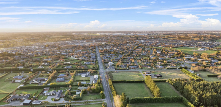
Wigram history is unusually visible for a Christchurch suburb. Roads such as The Runway, Corsair Drive, Kittyhawk Avenue and Skyhawk Road are not branding ideas from a blank subdivision plan. They point back to RNZAF Wigram, the former military airbase that shaped this part of south-west Christchurch for most of the 20th century.
For buyers looking at Wigram now, that history matters because it explains the suburb’s layout, street names, landmarks, reserves and sense of identity. Wigram Skies grew from a large, single-purpose airfield into a planned residential community with shops, schools, parks and connections to Hornby, Halswell, Aidanfield and the central city.
WWII origins of Wigram airbase
Wigram started before World War II
Strictly speaking, Wigram did not begin in World War II. Its aviation story started during World War I, when Sir Henry Wigram backed the Canterbury Aviation Company and a flying school at Sockburn in 1916. The purpose was practical: New Zealand needed trained pilots, and Christchurch had flat land suitable for early aircraft.
In 1923, the government took over the flying school and airfield. The site became Wigram Aerodrome, named after Sir Henry Wigram, who had been Mayor of Christchurch from 1902 to 1903 and was one of the country’s strongest early aviation supporters.
Why World War II changed Wigram’s role
World War II turned Wigram from an important local aviation site into a key part of New Zealand’s military training system. Aircraft, instructors, recruits and technical staff all became part of a larger wartime effort. Wigram’s flat runways and existing training culture made it well placed to support the Royal New Zealand Air Force as demand for trained personnel grew.
The Air Force Museum of New Zealand records that it stands on the site of the former Wigram air base and preserves New Zealand military aviation history. Its own history can be checked at the Air Force Museum of New Zealand.
The RNZAF years (1923–1995)
A training base with national importance
From 1923 to 1995, RNZAF Wigram was one of New Zealand’s best-known air force bases. It was closely associated with pilot training, recruit training, navigation training and other air force functions. For many people who served in the RNZAF, Wigram was either where they trained or where their service life began.
The base also became part of Christchurch’s civic memory. Families attended open days, air displays and commemorations. Aircraft movements were part of the soundscape of the south-west city. For decades, Wigram was not a suburb in the modern residential sense. It was a working defence and aviation place.
The Southern Cross landing
One of Wigram’s most famous moments came in September 1928, when Charles Kingsford Smith and Charles Ulm completed the first successful trans-Tasman flight in the Southern Cross. The aircraft landed at Wigram after leaving Australia. Contemporary accounts record a huge Christchurch crowd turning out to witness the arrival.
That event still matters because it shows Wigram’s place in early international aviation, not only local air force history. It also explains why heritage markers and aviation-themed names remain a natural fit in the suburb rather than decorative nostalgia.
The base closes
RNZAF Base Wigram closed in 1995 after defence property changes and consolidation across the air force. Training and other functions were moved elsewhere, including RNZAF Base Ohakea and RNZAF Base Woodbourne. The closure ended more than 70 years of formal RNZAF use at Wigram.
After 1995, the airfield did not immediately become housing. Aviation activity continued for a time on parts of the site, but the long-term direction had changed. The question became how a large, well-located piece of former defence land should be used inside a growing city.
Decommission and rezoning
From military land to urban land
The change from Wigram airbase to Wigram Skies was not a simple matter of closing a gate and building houses the next day. Large sites need planning, infrastructure, road connections, stormwater design, services, reserves and zoning decisions. The former airfield was a rare parcel: open, flat and close to existing employment areas, schools, arterial roads and the south-west growth edge of Christchurch.
Wigram Aerodrome’s final closure as an airfield came in 2009. By then, Christchurch was already under pressure to provide more well-planned housing areas. After the 2010 and 2011 Canterbury earthquakes, that pressure increased across the city.
Why the site suited a master-planned suburb
Former airfields can suit redevelopment because they often have large landholdings under single or limited ownership. That can make it easier to plan roads, open spaces, neighbourhood centres and staged land release. Wigram had another advantage: its history gave the area a clear identity from day one.
Christchurch City Council’s planning role is part of the wider story because subdivision and land-use change sit within council processes. For current council information, the cleanest starting point is Christchurch City Council.
Ngāi Tahu Property and master-planning
Who developed Wigram Skies
Wigram Skies was developed by Ngāi Tahu Property, the property development and investment arm associated with Ngāi Tahu. The project took the former airfield and planned it as a residential community, rather than a scatter of unrelated subdivisions. Ngāi Tahu Property describes itself as a significant New Zealand residential property developer with work across Christchurch, Queenstown and Auckland. Its current corporate information is available at Ngāi Tahu Property.
The Wigram Skies history is important because the development retained visible links to the airbase. The old runway alignment influenced The Runway, now one of the suburb’s main streets. Aviation names are used throughout the area, giving Wigram a stronger place story than many newer suburbs.
What master-planning changed
Master-planning matters most when a suburb has to work at daily-life scale. Residents need more than sections and roads. They need local shops, walking routes, playgrounds, schools, bus routes and safe vehicle connections. Wigram Skies was planned around those practical needs.
The Landing became the suburb’s main local retail and service centre. Wigram Primary School, Te Piki Kāhu, relocated to The Runway in 2019. Local parks and reserves were included through the wider neighbourhood, and the suburb connects to surrounding areas through routes such as Awatea Road, Springs Road, Curletts Road and the Wigram-Magdala link.
For people comparing new homes in Wigram, this planned structure is one of the main differences between Wigram Skies and older piecemeal growth areas. The suburb was designed after the airbase era, so its streets, sections and facilities reflect more recent expectations for residential living.
Wigram Skies today
A suburb with its history still in view
As at June 2026, Wigram Skies is an established Christchurch suburb rather than a future concept. The former Wigram airbase is now a mix of homes, local retail, parks, community facilities, heritage references and nearby employment land. The change is easy to see on the ground: aircraft hangars and museum buildings sit near modern streets, townhouses, stand-alone homes and neighbourhood reserves.
The Air Force Museum Wigram remains one of the suburb’s strongest anchors. It is located at 45 Harvard Avenue and, as at June 2026, the museum lists daily opening hours of 9.30am to 4.30pm, except Christmas Day. It is free for New Zealanders and people living in New Zealand, with an international visitor charge introduced in 2025.
Everyday amenities
Modern Wigram is popular because it works for normal weekly routines. Residents have The Landing for supermarket shopping, food, health services and hospitality. There are parks within the subdivision, larger recreation options nearby, and road links to Hornby, Halswell, Riccarton, Addington and Christchurch Airport.
The suburb also sits close to employment areas around Wigram, Sockburn, Hornby and Middleton. That mix of housing, shops and nearby jobs helps explain why the area has grown quickly since redevelopment began. For a practical look at shops, parks, transport and services, see our guide to Wigram amenities today.
What’s next for the suburb
More maturity, less frontier growth
The next stage of Wigram’s story is likely to be about maturity. Early development areas often feel new and unfinished for several years. By June 2026, Wigram has moved past that stage in many streets. Trees are growing, local businesses are established, school and childcare patterns are clearer, and buyers can judge the area from lived reality rather than plans alone.
Future change is likely to focus on infill, remaining sites, transport improvements, commercial tenancy changes and the continued role of the Air Force Museum. The museum’s presence gives Wigram a long-term cultural asset that most new suburbs do not have.
What the history means for buyers
For home buyers, Wigram history is not only a nice backstory. It affects how the suburb feels and functions. The former airfield gave the area scale. The master plan gave it structure. The aviation heritage gave it identity. The result is a suburb where new housing sits beside a nationally important military aviation story.
That does not make every property the same. Buyers should still compare section size, sun, garaging, street position, body corporate arrangements where relevant, school zones, commute times and future resale appeal. But Wigram’s shift from RNZAF Wigram to Wigram Skies gives the suburb a clear point of difference in Christchurch’s south-west.
Frequently Asked Questions
When did Wigram stop being an airbase?
RNZAF Base Wigram closed in 1995, ending its formal role as a Royal New Zealand Air Force base. Some aviation activity continued after the military closure, but the wider direction of the land changed from defence use toward civilian redevelopment. Wigram Aerodrome finally stopped operating as an airfield in 2009. That distinction is useful: 1995 marks the end of the RNZAF base, while 2009 marks the end of the airfield’s operating life.
Who developed Wigram Skies?
Wigram Skies was developed by Ngāi Tahu Property. The company planned the former airfield as a residential community with local streets, reserves, retail and services. The development kept strong aviation references, including The Runway and street names linked to aircraft and flight. That is why the Wigram Skies history still feels connected to RNZAF Wigram rather than being a completely fresh suburb with no visible link to the land’s earlier use.
Can you still visit the Air Force Museum?
Yes. As at June 2026, the Air Force Museum of New Zealand is open at 45 Harvard Avenue, Wigram. The museum says it is open daily from 9.30am to 4.30pm, except Christmas Day. Entry is free for New Zealanders and people living in New Zealand, while international visitor tickets apply. The museum is the best public place to understand RNZAF Wigram, the former Wigram airbase and New Zealand’s wider military aviation story.
Why is Wigram called Wigram?
Wigram is named after Sir Henry Wigram, a former Mayor of Christchurch and early aviation supporter. He helped establish the Canterbury Aviation Company and flying school at Sockburn in 1916. When the government later took over the airfield for military aviation, the Wigram name became attached to the base and then to the suburb. The name is therefore linked directly to Christchurch’s early aviation history, not to a marketing name created for Wigram Skies.